Londonist’s roundup of cutaway maps – many from the outstanding Transport Museum in Covent Garden – combines the nerdy excitement of hidden tunnels with the aesthetic pleasure of isomorophic cutaway art, along with some interesting commentary on both the development of subterranean tunnels and works and the history of representing the built environment underground in two-dimension artwork.
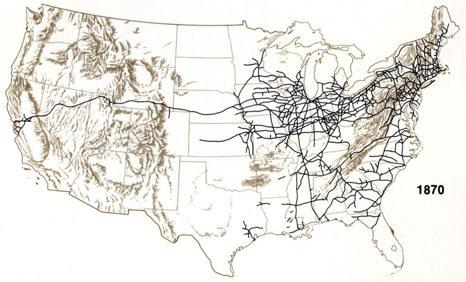
A map of about every primary passenger railway in the USA for 2016, commuter rail included.
Surely there are more trains lines about than this ?!
Nope. We’re animals. I’ve only trailed by train twice in the U.S., and it was the same line, once DC to Philadelphia, and once DC to NYC for work once I discovered the train was two hours faster than flying and cabbing back into NYC.
I do forget though that you guys fly everywhere and trains might not be practical. I live on an island the size of one of your states !
Fun fact: the busiest railway station in America (Penn Station in New York City) gets fewer passengers than Liverpool Central.
I knew the US had a much less extensive rail infrastructure than us, but bloody hell, the fact that there are ENTIRE STATES that literally don’t have passenger rail is madness.
I’d still love to travel on it some time, mind.
Just imagine the jobs you could create by building a decent railway system!
Behold, the end result of graft and political corruption.
I had no idea most of the US had no regional lines? Like, I live in tiny little MA with one of those clusters of red. Does everybody else have to DRIVE???
yes. we drive. and it’s terrible.
D: This is actually distressing.
to be fair some cities do have good bus systems
but….yeah.
what the shuddering fuck? That’s IT?!
actually we used to have a lot more, but as far as i’m aware i’m pretty sure the car companies bought a lot of railways and then destroyed them to force people to buy cars
Also some of those states that don’t have rails also have more cows than people.
Also our trains are slow and it’s usually much faster to drive than to take a train. We don’t have those speed rail things.
My super advanced mapmaking technique – a handful of dice makes the map nice
interesting method
My question is do the die affect topography any or just set the borders?
I imagine it’s up to the person making the map. But maybe the more dice in a single spot, the more mountainous or forested the area. Maybe choose a few dice to be deemed cities, and some dice for ruins.
Maybe let the dice choose, like a nat 20 would be the world capital, and 10’s would be mountains or something like that.
1-5: Plains and fields
6-8: Forests
9-11: Mountains
12-14: Tundras and snow covered lands
15-17: Farms and towns
18-19: Larger cities
20: Capitals and castles
what would happing if all the dice landed on a 20?
then you have a very busy continent
not all of those are d20s though, so you’d have to come up with another method for the other ones
Adjusted for all dice you might have
D20
1-5: Plains and fields
6-8: Forests
9-11: Mountains
12-14: Tundras and snow covered lands
15-17: Farms and towns
18-19: Larger cities
20: Capitals and castles
D12
1-3: Plains and fields
4-6: Forests
7-8: Mountains
9-10: Tundras and snow covered lands
11: Farms and towns
12: Larger cities
D10
1-3: Plains and fields
4-6: Forests
7-8: Mountains
9: Tundras and snow covered lands
10: Farms and towns
D8
1-4: Plains and fields
5-6: Forests
7: Mountains
8: Tundras and snow covered lands
D6
1-3: Plains and fields
4: Forests
5-6: Mountains
D4
1-2: Plains and fields
3: Forests
4: Mountains
Holy shit. Definitely using this.
I swore at how simple this motherfucking thing is. You’re all bastards and i love you.


