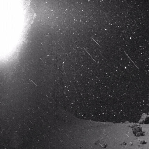
Remember Rosetta? That comet-chasing European Space Agency (ESA) probe that deployed (and accidentally bounced) its lander Philae on the surface of Comet 67P? This GIF is made up of images Rosetta beamed back to Earth, which have been freely available online for a while. But it took Twitter user landru79 processing and assembling them into this short, looped clip to reveal the drama they contained.
while the stuff in the foreground is dust/ice on the surface of the comet itself, the background is actually stars. i saw a stabilized video where you can really make it out, and it blew my mind.
here’s the stabilized clip, if anyone’s interested
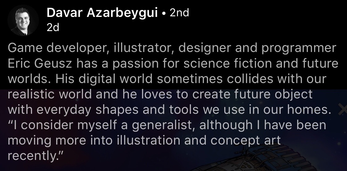
Earth is a complex, dynamic system. For 60 years, we have studied our changing planet, and our understanding continues to expand with the use of new technologies. With data from satellites, instruments on the International Space Station, airborne missions, balloons, and observations from ships and on land, we track changes to land, water, ice, and the atmosphere. Application of our Earth observations help improve life now and for future generations. Since we opened for business on Oct. 1, 1958, our history tells a story of exploration, innovation and discoveries. The next 60 years, that story continues. Learn more: https://www.nasa.gov/60
Make sure to follow us on Tumblr for your regular dose of space: http://nasa.tumblr.com.
This one is technically not yet history, because at the time of posting, the little craft has about half an hour left to go. That said, let’s proceed.
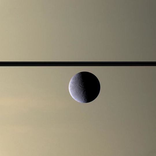
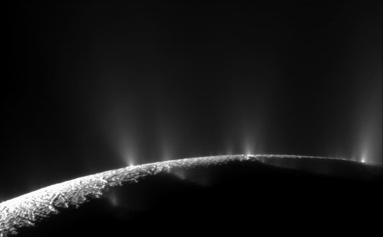
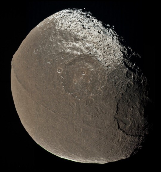
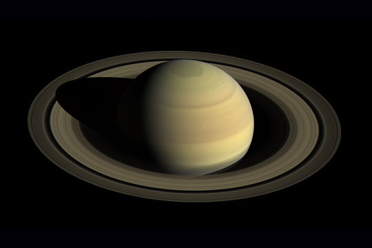
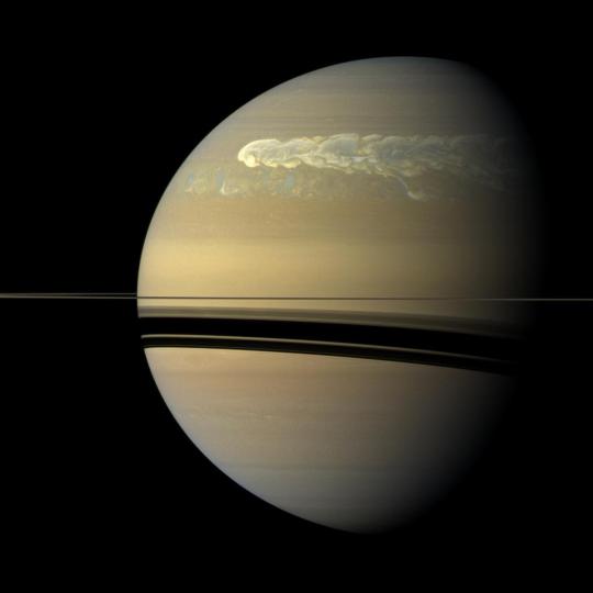
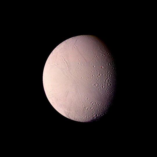
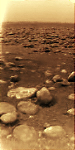
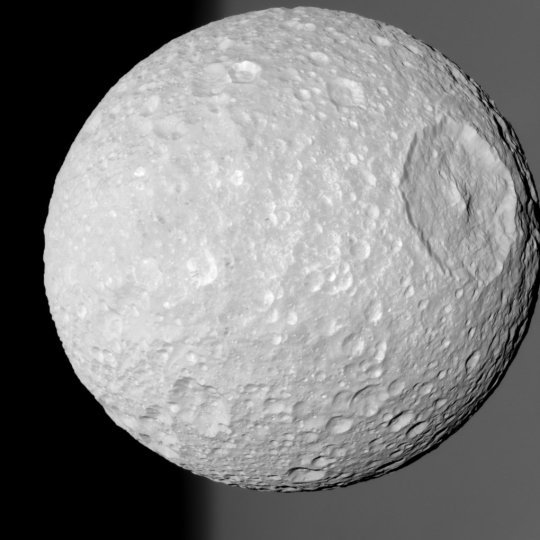
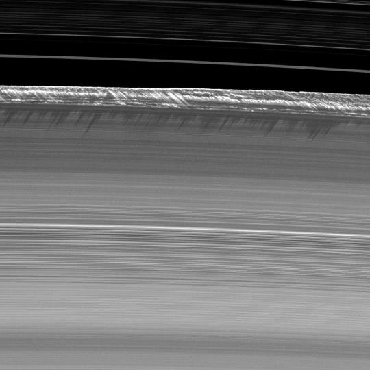
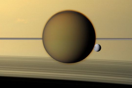
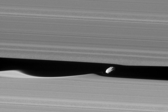
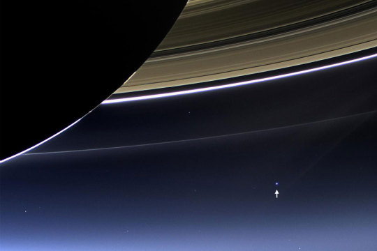
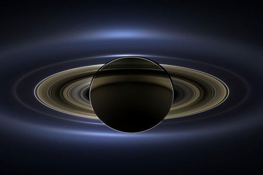
In 2017, NASA’s Cassini space probe ended its twenty-year mission at Saturn. After a nearly-seven-year-long journey there, it orbited the ringed planet for 13 years and just over two months, gathering copious amounts of information about the planet, said rings, and many of its moons. It landed an ESA probe called Huygens on Titan, the first-ever soft landing in the outer Solar System. It discovered lakes, seas, and rivers of methane on Titan, geysers of water erupting from Enceladus (and passed within 50 miles of that moon’s surface), and found gigantic, raging hurricanes at both of Saturn’s poles.
And the images it returned are beautiful enough to make you weep.
On this day in 2017, with the fuel for Cassini’s directional thrusters running low, the probe was de-orbited into the Saturnian atmosphere to prevent any possibility of any contamination of possible biotic environments on Titan or Enceladus. The remaining thruster fuel was used to keep the radio dish pointed towards Earth so the probe could transmit information about the upper atmosphere of Saturn while it was burning up due to atmospheric friction.
This is us at our best. We spent no small amount of money on a nuclear-powered robot, launched it into space, sent it a billion miles away, and worked with it for two decades just to learn about another planet. And when the repeatedly-extended missions were through, we made the little craft sacrifice itself like a samurai, performing its duty as long as it could while it became a shooting star in the Saturnian sky.
Rhea occulting Saturn
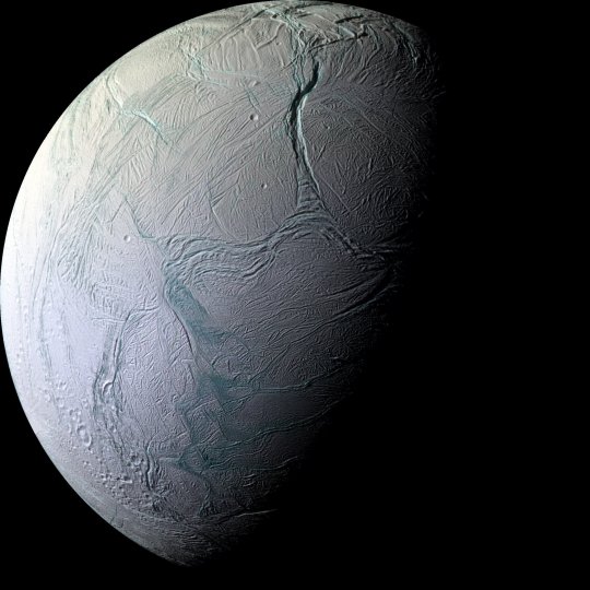
Water geysers on Enceladus
Strange Iapetus
Look at this gorgeousness
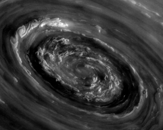
A gigantic motherfucking storm in Saturn’s northern hemisphere
Tethys
This image is from the surface of a moon of a planet at least 746 million miles away. Sweet lord
Mimas
Vertical structures in the rings. Holy shit
Titan and Dione occulting Saturn, rings visible
Little Daphnis making gravitational ripples in the rings
That’s here. That’s home. That’s all of us that ever lived.
yanno those white noise sites like rainymood.com or the cafe shop one? i’d like an Enterprise bridge one, please. Soft beeping, maybe some chill version of amok time theme or something, and every now and then the crew calmly issuing orders or reading something sciency. im watching the lights of zetar and this evasive scene? is super calming and i need it on infinite repeat somehow. someone make this happen.
SO APPARENTLY I AM NOT THE ONLY PERSON WHO WANTED SOMETHING LIKE THIS
We’re set to launch ICESat-2, our most advanced laser instrument of its kind, into orbit around Earth on Sept. 15. The Ice, Cloud and land Elevation Satellite-2 will make critical observations of how ice sheets, glaciers and sea ice are changing over time, helping us better understand how those changes affect people where they live. Here’s 10 numbers to know about this mission:
One Space Laser
There’s only one scientific instrument on ICESat-2, but it’s a marvel. The Advanced Topographic Laser Altimeter System, or ATLAS, measures height by precisely timing how long it takes individual photons of light from a laser to leave the satellite, bounce off Earth, and return to ICESat-2. Hundreds of people at our Goddard Space Flight Center worked to build this smart-car-sized instrument to exacting requirements so that scientists can measure minute changes in our planet’s ice.
Sea ice is seen in front of Apusiaajik Glacier in Greenland. Credit: NASA/JPL-Caltech/Jim Round
Two Types of Ice
Not all ice is the same. Land ice, like the ice sheets in Greenland and Antarctica, or glaciers dotting the Himalayas, builds up as snow falls over centuries and forms compacted layers. When it melts, it can flow into the ocean and raise sea level. Sea ice, on the other hand, forms when ocean water freezes. It can last for years, or a single winter. When sea ice disappears, there is no effect on sea level (think of a melting ice cube in your drink), but it can change climate and weather patterns far beyond the poles.
3-Dimensional Earth
ICESat-2 will measure elevation to see how much glaciers, sea ice and ice sheets are rising or falling. Our fleet of satellites collect detailed images of our planet that show changes to features like ice sheets and forests, and with ICESat-2’s data, scientists can add the third dimension – height – to those portraits of Earth.
Four Seasons, Four Measurements
ICESat-2’s orbit will make 1,387 unique ground tracks around Earth in 91 days – and then start the same ground pattern again at the beginning. This allows the satellite to measure the same ground tracks four times a year and scientists to see how glaciers and other frozen features change with the seasons – including over winter.
532 Nanometer Wavelength
The ATLAS instrument will measure ice with a laser that shines at 532 nanometers – a bright green on the visible spectrum. When these laser photons return to the satellite, they pass through a series of filters that block any light that’s not exactly at this wavelength. This helps the instrument from being swamped with all the other shades of sunlight naturally reflected from Earth.
Six Laser Beams
While the first ICESat satellite (2003-2009) measured ice with a single laser beam, ICESat-2 splits its laser light into six beams – the better to cover more ground (or ice). The arrangement of the beams into three pairs will also allow scientists to assess the slope of the surface they’re measuring.
Seven Kilometers Per Second
ICESat-2 will zoom above the planet at 7 km per second (4.3 miles per second), completing an orbit around Earth in 90 minutes. The orbits have been set to converge at the 88-degree latitude lines around the poles, to focus the data coverage in the region where scientists expect to see the most change.
800-Picosecond Precision
All of those height measurements come from timing the individual laser photons on their 600-mile roundtrip between the satellite and Earth’s surface – a journey that is timed to within 800 picoseconds. That’s a precision of nearly a billionth of a second. Our engineers had to custom build a stopwatch-like device, because no existing timers fit the strict requirements.
Nine Years of Operation IceBridge
As ICESat-2 measures the poles, it adds to our record of ice heights that started with the first ICESat and continued with Operation IceBridge, an airborne mission that has been flying over the Arctic and Antarctic for nine years. The campaign, which bridges the gap between the two satellite missions, has flown since 2009, taking height measurements and documenting the changing ice.
10,000 Pulses a Second
ICESat-2’s laser will fire 10,000 times in one second. The original ICESat fired 40 times a second. More pulses mean more height data. If ICESat-2 flew over a football field, it would take 130 measurements between end zones; its predecessor, on the other hand, would have taken one measurement in each end zone.
And One Bonus Number: 300 Trillion
Each laser pulse ICESat-2 fires contains about 300 trillion photons! Again, the laser instrument is so precise that it can time how long it takes individual photons to return to the satellite to within one billionth of a second.
i’ll see your space australians and raise you: space eastern europeans.
like space australians, but comically deadpan
‘there was a critical systems failure and now we’re dead in space! we need to evacu–’ *chief engineer antonov thumps control panel with fist* ‘oh, we’re. we’re okay.’
someone has either pickled a vegetable or distilled alcohol in a container that was intended for neither, in zero gravity
there’s a little old lady on this crew. nobody knows why. nobody suspects she’s the head of an espionage network either
*exasperated muttering over comms line during repair eva* ‘what’s that?’ ‘i said this thing has ‘made in usa’ written on it and no fucking wonder *deliberately heavy accent* exkyooz my language’
improvised electrical device breaks safety regulations in 72 systems. ‘what? it woks.’
somebody is talking about The Revolution. ‘andrei please that was 2723 years ago’ ‘my father fought in it’
‘here’s a good one: is it possible to introduce communism in the frozen world of OGLE-2005-BLG-390Lb?’ confused alien: ‘i don’t know?’ ‘in principle yes, but after the first five year plan they would have to import ice’
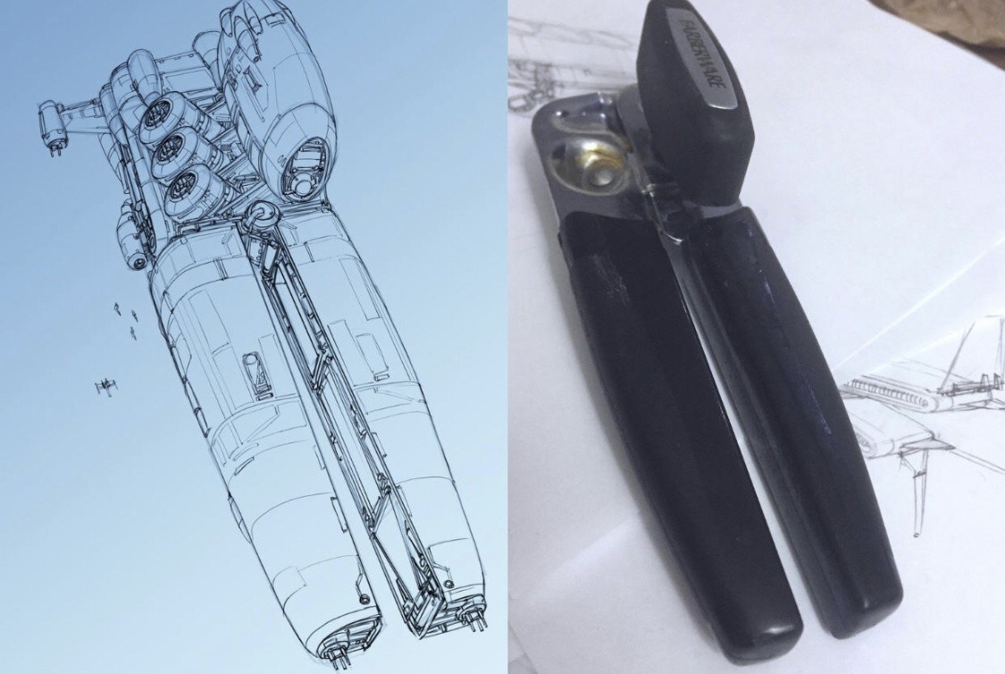
the trabant, but now it’s a space ship
THE TRABANT, BUT NOW IT’S A SPACE SHIP
👆🏻To me, the trabant as a space capsule is entirely believable.